
Gangani Danga: Bengal's Grand Canyon
Where the earth glows red and the land itself tells stories of fire
(All pictures by author)
The Bengali word khoai makes people instantly think of Santiniketan. The badlands around Santiniketan in Birbhum, locally called Khoai, a derivation of the Bengali word for erosion khshoy, have been receiving unwavering attention since Santiniketan was founded in the late 19th century. But tucked away in West Medinipur, near Garbeta town, lies another badland that equals, if not surpasses, the one in Santiniketan. The place is called Gangani, also known as the Grand Canyon of Bengal. And it will take more than one visit to fully grasp the gorgeousness of this place.
A river and its ravines
Gangani sits on the right bank of the river Shilabati, a non-perennial river originating in what is now Jharkhand and flowing eastward to merge with the Dwarakeswar River near the town of Ghatal in the Paschim Medinipur district of West Bengal. West Bengal has quite a few rivers that follow this course. The mighty Damodar, Ajay and the Kangshabati, considered a twin of the Shilabati river, are a few notable examples.
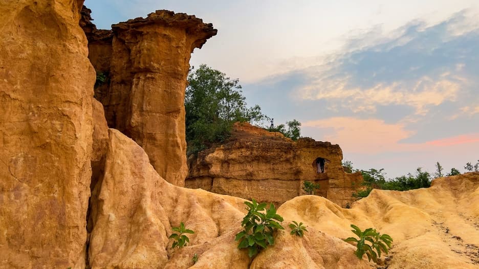
Standing on the edge of the Gangani gorge, one is immediately struck by the strange geometry of the land. What stretches out below is a labyrinth of narrow gullies, sharp ridges and steep earthen cliffs that seem to twist and turn in every direction. The red lateritic soil rises in irregular towers and ridgelines, as if the earth itself had been sculpted into a series of natural fortresses. In some places the formations resemble miniature mesas and buttes, while elsewhere the ground drops suddenly into deep ravines carved by aeons of erosion. From above, the landscape looks almost like a frozen wave of earth caught in motion.
A landscape that changes with the seasons
The appearance of the gorge changes considerably with the seasons. During the dry months of summer, the exposed red soil gives Gangani a stark and almost otherworldly appearance, with the sun beating down on the bare ridges and the gullies lying in sharp shadow. With the arrival of the monsoon, however, the surrounding landscape turns lush and green. The Shilabati river swells with rainwater and the banks are dotted with patches of fresh vegetation, creating a vivid contrast with the rust-coloured cliffs. Winter perhaps offers the most pleasant time to visit, when the air is crisp, the sky is clear and the contours of the badlands stand out in striking clarity.
But it is during the late afternoon that Gangani reveals its most dramatic face. As the sun begins its descent, the red cliffs catch the slanting light and glow in shades of burnt orange and deep crimson. Long shadows stretch across the gullies, accentuating the rugged texture of the terrain. The pale sandbanks along the Shilabati reflect the fading sunlight, adding a soft golden hue to the scene. For a brief period before dusk, the entire gorge appears bathed in warm light, transforming the badlands into a landscape that is at once austere and achingly beautiful.
It is perhaps this fiery glow of the cliffs that has given the place its evocative local name. The Garbeta badlands are widely known as Gangani Danga: literally, the land of fire.
Bhima, Bakasur and a scarred earth
Local folklore attributes Gangani's jagged terrain to Bhima's battle with the man-eating demon Bakasur. According to the local retelling of the Mahabharata, their titanic struggle here scarred the earth, leaving the ravines seen today. The story has been doing the rounds in the area around Garbeta, where people believe the demon's defeat reshaped the land itself in that legendary confrontation long ago.
How a badland is born
Badland, a direct translation of mako sica, a Native American word for barren land, is geologically speaking any parched, highly eroded landscape characterised by a maze of steep slopes, sharp ridges and deep gullies carved into soft sedimentary rock and clay-rich soils by the relentless forces of wind and water. The Chambal ravines in Central India are the most famous example of an Indian badland.
Geomorphologically, we can trace the Gangani badlands to the Pleistocene era, which lasted from about 2.5 million years ago to roughly 11,000 years ago. This region sits on the edge of the Chhotanagpur Plateau, a massive, ancient upland region in eastern India primarily covering Jharkhand and parts of Odisha, Chhattisgarh and West Bengal. Over long geological periods, sediments washed down from this plateau were deposited along the course of the Shilabati river.
Much of this material consists of lateritic soil, rich in iron and easily susceptible to erosion when exposed to rain and flowing water. During the monsoon months, seasonal torrents of rainwater rush down the slopes and cut into these soft deposits, gradually carving narrow channels and gullies. As the river shifts course and seasonal runoff continues to eat away at the banks, these channels deepen and widen, eventually forming the steep ridges and ravines that characterise a badland landscape.
Gangani is thus a fascinating gorge of red earth on the banks of the Shilabati, sculpted over thousands of years by the persistent forces of monsoon rain, river flow and wind erosion. The result is the row of jagged cliffs and undulating gullies, punctuated by pale sandbanks, that give this landscape its distinctive and striking appearance.
Practical Information for visitors
Best time to visit: Winter, from November to February, for crisp air and clear skies. Late afternoon visits are especially rewarding, when the cliffs glow in shades of orange and crimson.
Getting there by road: Gangani is roughly 170km from Kolkata, about 4 to 5 hours by road. Take NH16 towards Kharagpur and branch off towards Garbeta via Chandrakona Road.
Getting there by train: Regular trains from Howrah towards Midnapore, Adra and Purulia stop at Garbeta railway station. From Garbeta, local auto-rickshaws and totos reach the gorge in about fifteen minutes.
On arrival: A gentle flight of stairs has been built into the gorge to help visitors navigate the terrain comfortably.